
A cold snap is on the way from Tuesday night onwards.
Met Éireann says freezing temperatures, hail and fog will be seen throughout the rest of the week.
Following an exceptionally mild February to date, temperatures on Tuesday night will fall between 0 and 4 degrees after rain clears with the potential for some frost and icy patches in sheltered spots.
Wednesday will be a noticeably colder day with sunshine and widespread blustery showers. Some of the showers will be heavy with hail and a risk of isolated thunderstorms, and a few may turn wintry over hills and mountains, especially towards the evening.
The weather will remain cold but with a shift to increased sunny spells as we move into the weekend.
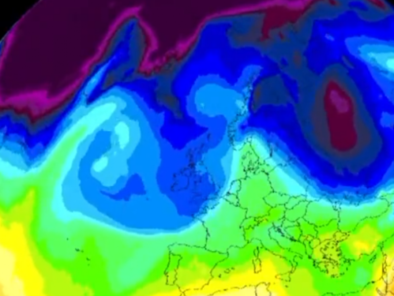
Windchill forecast for the next few days, you can see the drop in windchill from tomorrow night. pic.twitter.com/uH58CzG0Vd
— Carlow Weather (@CarlowWeather) February 20, 2023
Alan O'Reilly from Carlow Weather, says the weather ahead of this week's cold spell will be a mixed bag:
"It'll still be very cloudy, but temperatures will get up above 10 degrees for Monday and Tuesday", said Alan.
"Some showers about but generally not too much rainfall until Tuesday night when we will see a band of rain cross the country"
Still showery on Wednesday with a risk of some of those showers being wintry in the west, northwest and on higher ground."
It's worth noting that this cold spell is not connected with the widely reported 2023 Beast from the East. The long-mooted weather event remains too far away to be forecast with any meaningful accuracy.
The possibility of such an event, however, is increasingly likely. Taking to Twitter this morning, Alan O'Reilly from Carlow Weather said "the models [are] really starting to show high pressure building to North of us next week. Long way out yet but this could become a trend and if high sets up there then the risk of a colder start to March really increases."
The models really starting to show high pressure building to North of us next week. Long way out yet but this could become a trend and if high sets up there then the risk of colder start to March really increases. pic.twitter.com/9dTewye55o
— Carlow Weather (@CarlowWeather) February 20, 2023