
By Robbie Byrne
Have we skipped summer and bounced straight back into winter?
Let's hope that isn't the case, but it looks increasingly likely that the current cold snap could stick around until at least the middle of April.
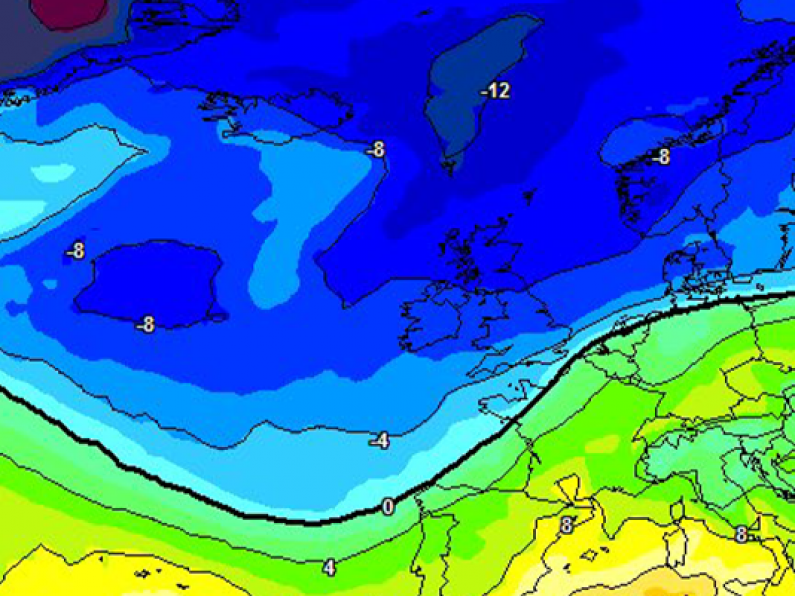
A different view of the same charts, showing northern hemisphere. You can see the Arctic air dropping down into Western Europe. The good news is that there will very little rain over the next 7 days. Dry and cold beats mild and wet, right? pic.twitter.com/1unfqsiWxW
— Carlow Weather (@CarlowWeather) April 6, 2021
Temperatures will recover slightly tomorrow (Thursday), but that respite will be short-lived as another icy blast of polar air extends over the South East on Friday night.
That cold air mass will stick around for the weekend at the very least, with current weather models forecasting a prolonged continuation of the unseasonable weather into the middle of April.
Temperatures across the weekend will be well below average, with daytime highs of 6 or 7 degrees celsius before dropping to minus figures at night.
It's been a cold week so far, but tomorrow temperatures will recover a little 📈 before the next cold plunge of air arrives towards the weekend 📉
If you’re out planting in the garden this week be aware of potential severe frosts on the way! 🌼🥶
📰👉🏾 https://t.co/QvaKYgR51A pic.twitter.com/EaHnx7hxd6
— Met Éireann (@MetEireann) April 6, 2021
Taking to Twitter earlier today, weather expert Alan O'Reilly said: "Upper air charts from GFS weather model [shows] it will turn colder again for the weekend. No sign of any real heat returning at present. Don’t shoot the messenger though... The good news is that there will very little rain over the next 7 days. Dry and cold beats mild and wet, right?"
As Alan said, the upside of all this cold weather is a noticeable lack of precipitation, with Met Éireann forecasting little to no rain and prolonged spells of unbroken sunshine over the next five days.