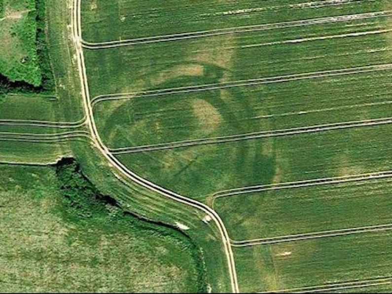

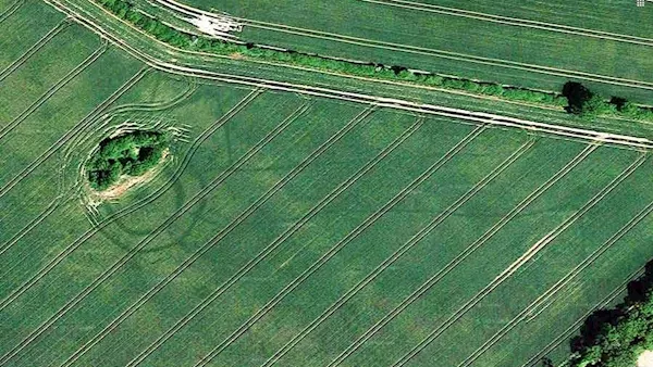
A huge number of previously unknown monuments, mostly located in crop fields, discovered during last summer’s heatwave are visible on the latest Google Maps/Google Earth.
That’s according to Anthony Murphy of Mythical Ireland, who with Ken Williams found the first and most well-known discovery of the heatwave - a previously unknown henge near Newgrange which continues to make international news.
Mr Murphy has been examining the new Google images and said as a result he has “discovered a huge number of previously unknown monuments, most of them located in crop fields in the tillage-rich areas of seven different counties.”

“These are Meath, Dublin, Kildare, Carlow, Wicklow, Laois and Kilkenny, which are covered by the June 2018 satellite images which have recently been added to Google Maps/Google Earth.”
He said that in many cases there are no marks or traces left on the surface so “the farmers and landowners will be unlikely to know they even exist.”
He believes that some are “small ring-ditches, maybe 20m or 30m in diameter, but there are some truly enormous structures like ringforts and enclosures, in some cases measuring 100m in diameter and more. The largest structure visible in the Google imagery is in Co. Dublin and measures a staggering 350m wide.”
In October last year the Department of Culture, Heritage and the Gaeltacht said the heritage sites newly discovered during the summer heatwave near Newgrange in Co Meath, “have the potential to transform our understanding of that landscape.”
At the time it released a list of 71 new national monuments in 12 counties reported to it from June to August this year.
It said the majority were in counties Louth and Meath, with 13 and 25 new monuments respectively, but discoveries were also made across the country and include possible rock art and prehistoric art as well as enclosures, bronze age cemeteries, ring-ditches, souterrains, ecclesiastical enclosures and a road.
New Google Earth satellite imagery showing parts of Ireland at the end of June 2018 reveals significant numbers of archaeological sites. Images supplied by Anthony Murphy