
By Vivienne Clarke
A leading climatologist has defended Met Éireann and its predictions of Storm Elsa which hit the west coast of Ireland on Wednesday night leading to severe flooding in Galway City.
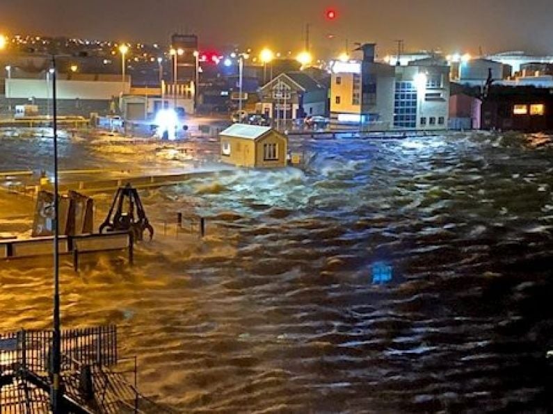
Up to 50 cars and 10 houses were flooded after Storm Elsa swept through Galway that night, while a transport ship that operates between the Port of Galway and the Aran Islands broke free of its moorings during the storm.
John Sweeney, emeritus professor of geography at Maynooth, pointed out that a Yellow alert had been issued that day by Met Éireann and that the public should have paid closer attention to the warning.
“The message of what happened in Galway is to take very seriously the weather warnings from Met Éireann which were going out all day long on Wednesday, saying there was uncertainty and saying that you have to listen closely to the forecast over the coming hours.
“In that situation if you want to park your car on the sea front with the high tide coming in, with a storm being forecast there's certainly a risk that you should be aware of,” he told RTÉ radio’s Morning Ireland.
It's rather ironic in this particular case that in many instances people parked their car on the seafront with Storm Elsa coming in and went off to see a film in the cinema called Frozen of which Elsa is the star.
Professor Sweeney said the message is quite clear – “be prepared, be listening to forecast.
He said: "The weather forecast from Met Éireann is the best you can get, the models are state-of-the-art models and yes, things will go wrong, there will be uncertainty in any forecast, especially on the west coast of Ireland, you have to expect the unexpected.
“I think it was very difficult for Met Éireann, the circumstances were not consistent about just how soon and how severe the storm would track up the west coast.
“It was rather like the opposite of what happened with Storm Lorenzo a few months back where the storm lingered off the west coast longer than the model predicted and didn't actually cause the chaos on land.
“It's quite clear that Met Éireann were doing the best they could in the circumstances, the Yellow alert after all warns that there is something that is potentially dangerous on a localised scale, certainly the west coast of Ireland is very much in the forefront of these kind of events.
Fire crews from Galway City and Athenry stations had rescued 15 motorists left trapped in their cars on the prom in Salthill.
Mr Sweeney said: “It's very difficult of course for you to calibrate the exact depth and intensity of a storm from models when you don't have offshore observations to do this. This was a deep storm, it was 968 hectopascals.
The problems of a hazard are not simply the problems of one event going wrong, in this case, the way the storm tracked up the west coast, it was producing a surge of water into Galway Bay at precisely the time the storm was arriving and at precisely the time high tide was being reached in Galway itself.
“So you had the joint probability of things going wrong all at the same time, in those circumstances of course the damage was much more severe than perhaps would have been the case if only one thing had gone wrong.
“It is interesting to note that had the same circumstances applied this time next week the tide would have been 1.3 metres higher, so, in a way maybe would have been much worse.
“Weather forecasting is still an inexact science we have models that sometimes contradict each other and it’s a judgement call, which one you believe especially in areas where the data is poor.”
The head of forecasting at Met Éireann, Evelyn Cusack defended their forecasts pointing out that there had been a Yellow warning on the day. “As the storm centre deepened, during the course of the evening – we upped the level to Orange, but unfortunately it wasn't enough notice to prevent that flooding of the car park.
“Normally we like to issue our storm warnings as early as possible, up to 48 hours ahead, unfortunately because of the uncertainty in the meteorological situation we were really only able to call it very close only about two hours ahead of high tide.”