
Crisis management teams across the country have been activated as Storm Jorge heads towards Ireland.
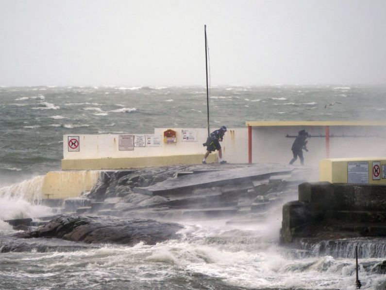
Met Eireann have issued a Status Red Wind warning for Galway and Clare`which predicts gusts of between 130km/hr and 145km/hr in the two counties between 1pm and 4pm on Saturday afternoon.
They also said there will be an elevated risk of coastal flooding.
Winds of 130 kilometres an hour are expected in western counties, where a status orange warning will come into effect tomorrow.
There is also more rain on the way, despite February already breaking records going back to the 1800s.
Up to 40,000 people could lose power this weekend as there will be heavy thundery downpours of rain and hail, and snow in places for a time in the morning.
A stormy day with very strong westerly winds and damaging gusts - as well as some further flooding - is forecast.
Met Éireann has issued an orange wind warning for Clare, Galway Kerry and Mayo from 6am on Saturday to 3am Sunday.
A warning will also be in place for Donegal, Leitrim and Sligo from 12.00pm Saturday to 3am Sunday.
The National Emergency Co-ordination group has met and is advising people to keep an eye on neighbours, stay away from the coast and take extra care on the roads.
Planning Minister Eoghan Murphy, meanwhile, warned that weather conditions will worsen over the weekend.
He said: "Damaging gusts are possible anywhere - this means that trees could come down anywhere.
"Met Éireann will be updating and possibly escalating their warnings later on this afternoon."
Minister Murphy said while the flooding risk will continue, there is also a risk of power outages over the weekend.
Fergus Griffin from the Defence Forces said there are plans in place to help people in areas at risk of flooding.
He said: "Since the 24th February, the Defence Forces has deployed 209 personnel in the preparation and maintenance of flood defences.
"We currently have 29 personnel deployed in the Castleconnel area of Limerick, and we stand ready to assist our colleagues in the local authority."
Brian Farrell from the Road Safety Authority (RSA) says drivers need to take extra care.
"What we're saying is that you do really need to be on guard for these conditions.
"It means slowing down, it means expecting the unexpected when you go round the next corner - particularly on local roads".
The RSA is asking road users to exercise caution while using the roads over the next few days.
Road users in areas affected are advised to check local traffic and weather conditions before setting out on a journey.
- The following advice is being given to motorists:
- Control of a vehicle may be affected by strong cross winds. High sided vehicles and motorcyclists are particularly vulnerable to strong winds.
- Beware of objects being blown onto the road. Expect road conditions to change quickly in high winds so reduce your speed
- Watch out for falling/fallen debris on the road and vehicles veering across the road
- Drivers should allow extra space between themselves and vulnerable road users, such as cyclists and motorcyclists as they may be blown off course by strong winds
- Drivers need to slow down in wet weather conditions, especially on high speed roads such as dual carriageways and motorways where there is increased danger of aquaplaning
- If the road ahead is flooded choose another route, do not attempt to drive through it
- Road users should always follow recommended routes and obey signs closing roads to traffic
- After going through water, drive slowly with your foot on the brake pedal for a short distance - this helps to dry the brakes
- Drive with dipped headlights at all times