
It may not feel like it in the afternoon sunshine, but it's about to turn a lot colder.
Temperatures will start to drop across the South East later this afternoon ahead of what is set to be a bitterly cold week.
As the night progresses, an Arctic airmass will move down over the country, increasing the likelihood of wintry falls.
Met Éireann has issued a Status Yellow ice warning from Monday at 18:00 to Tuesday at 10:00, warning of "hazardous conditions due to freezing temperatures including icy stretches on roads and paths."
What's more, it even appears we could get our first taste of these wintry falls as early as tonight.
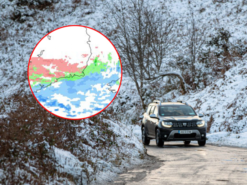
The latest high-resolution charts show a good chance of snow falling across the South East later tonight and into the early hours of tomorrow (Tuesday) morning, particularly across Kilkenny and Tipperary.
As we all know, forecasting snowfall in Ireland often leads to disappointment but it does seem the right ingredients are in place for a light dusting in places.
Taking to Twitter earlier today, Carlow Weather's Alan O'Reilly said: "Latest high-resolution weather models show showers could turn to sleet and snow in Southern areas tonight and also some wintry showers feeding into Northern areas."
Latest high resolution weather models show showers could turn to sleet and snow in Southern areas tonight and also some wintry showers feeding into Northern areas. pic.twitter.com/cXfcfLjAUw
— Carlow Weather (@CarlowWeather) March 6, 2023
As for the week ahead, Met Éireann says the outlook is "very cold with frost, ice and some possible wintry falls."
TUESDAY NIGHT: Another icy cold night with a widespread sharp or severe frost as temperatures fall to between -5 and 0 degrees. Mostly dry and clear over the northern half of the country, with wintry falls of rain sleet or snow in parts of the south.
WEDNESDAY: A very cold frosty start with icy stretches, but with a good deal of dry bright sunshine about too. Many areas will stay dry for the day in moderate east to southeast winds, though outbreaks of rain or sleet may continue over the southern half of the country. The highest temperatures will again range just 3 to 6 degrees.
WEDNESDAY NIGHT: Widespread wintry outbreaks may continue to feed up from the southwest through the night. Very cold in parts with lowest temperatures of -4 to + 0 degrees with light to moderate northeasterly breezes.
THURSDAY: Further wintry outbreaks continue through Thursday, with any snow turning to a mix of sleet and rain as the day progresses. A chilly day with the highest temperatures of 3 or 4 degrees, milder along the southern fringes. Mostly moderate easterly breezes. Cold again overnight with lows of -2 to +2 degrees.